Results

#1. Which of the following factors influence ocean currents?
#2. The highest salinity is found in which of the following lakes?
#3. The deepest lake of the world is
#4. Which one of the following sea is the largest in area?
#5. The biggest island of the Indian Ocean is
#6. Which one of the following ocean currents is different from others?
#7. Ox-bow lake is a feature formed by
#8. Which one of the following currents has a warming influence on the neighbouring coast?
#9. Which one is not a depositional land form developed by the running water?
#10. Which one of the following seas is the shallowest?
#11. Tsunamis are mainly produced by
#12. Which one of the following is different from others?
#13. Which one of the following ocean tides is caused by biological factors?
#14. Which one of the following is a warm ocean current?
#15. Gulf stream is
#16. The concept of sea floor spreading was first propounded by
#17. Coral reef extending along with eastern coast of Australia is
#18. Volcanic eruptions do not occurs in the
#19. Among oceanic trenches the deepest trench is
#20. Humboldt Current flows
#21. Canaries Current flows along
#22. The Agulhas Current flows in
#23. The colour of Yellow Sea is the result of
#24. What is the most abundant component of salts in sea ?
#25. Which one of the following is called marine snowfall?
#26. Which one of the following statements is not true about subsidence theory of Coral reefs?

#27. Consider the following statements and select the correct answer from the codes given below:

#28. Consider the following statements and select the correct answer from the code given below:

#29. Consider the following statements:

#30. The horizontal distribution of temperature of ocean water is largely affected by

#31. Match the following two lists and choose the correct answer from the codes given below:

#32. Which one of the following is the correct sequence of the terrigenous deposits from the coast to the deeper part of the sea? Use the codes given below to select the correct answer:

#33. The formation of the Mid-Atlantic Ridge is a typical example of the process of

#34. Which of the following is the correct order of current of the South Atlantic Ocean from Equator and back?

#35. Consider the following statements regarding the Tidal hypothesis:

#36. Match the List-I with List-II and select the correct answer from the codes given below:

#37. What is true about Nile?

#38. Match list I with list II and select the correct answer using the codes given below the lists:

#39. Which among the following statements characterized EI Nino?
#40. The deepest trenches of the ocean are found in
#41. Which of the following seas has the highest salinity?
#42. The Sargasso sea is a part of the
#43. The line drawn over a map joining points having similar amounts of salinity is known as
#44. Which of the following two gulfs are connected by Hormuz Strait?
#45. Which is the longest river of Europe?
#46. In which sea the river ‘Don’ flows in?
#47. Gaza strip lies along the coast of
#48. The Kiel canal connects
#49. The water fall ‘Victoria’ is associated with the river.
#50. The Great Barrier Reef is located on the coast of
#51. What is the name of the strait where Adams Bridge is situated?
#52. The strait which separates Asia from North America is
#53. What is true about Lake Superior ?
#54. The Lake Baikal is situated in the region of
#55. Which one of the following pairs is not correctly matched?

#56. Match List-I with List-II and select the correct answer using the code given below:
#57. Which one of the following is not correctly matched? Islands Ocean

#58. Which of the following seas are enclosed?
#59. The largest delta of the world is

#60. Match List-I with List-II and select the correct answer using the codes given below:

#61. This item consists of two statements, Statement I and Statement II.
#62. Which of the following seas/gulfs are connected by the Suez Canal?
#63. Which one of the following is the tide produced as a consequence of Moon and Sun pulling the Earth in the same direction?
#64. Which water body separates Australia from New Zealand?
#65. Tsunamis are not caused by

#66. Which of the following seas are enclosed?
#67. Which one of the following is a correct sequence in the increasing order of salinity concentration?
#68. Which one of the following is the correct sequence of the following topographical features found from upper to lower course of a river?
#69. Which one of the following pairs is not correctly matched?
#70. What is the similarity between Milwaukee Deep, Java Trench and Challenger Deep?
#71. Which one among the following best explains the reason for the Eastern and Western boundaries of the Pacific Ocean experiencing frequent earth-quake?
#72. Mr X has been invited to participate in a conference to be held at Buenos Aires. He has choosen the following shortest flight route Mumbai to Frankfurt (non-stop) Frankfurt to Sao Paulo (non-stop) Sao Paulo to Buenos Aires (non-stop) Which one of the following seas will likely to be flown over by Mr X ?
#73. Which one among the following sequences of water bodies, from lower to higher salinity concentration, is correct?
#74. The riverbank is weakest where the river turns. This is because water

#75. The following question consist of two statements. Statement I and Statement II. You are to examine these two statements carefully and select the answers to these questions using the codes given below.
#76. Which one among the following is a cold Ocean current?
#77. Which one among the following is a sea without having a coastline?

#78. Arrange the following features formed by rivers in its course starting from upstream:

#79. The following question consist of two statements, Statement I and Statement II. You are to examine these two statements carefully and select the answers to these questions using the code given below :
#80. In the absence of Cold Labrador Current, which one among the following would happen ?
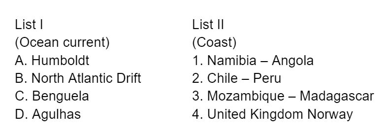
#81. Match List I with List II and select the correct answer using the code given below the Lists :
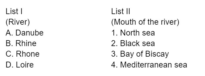
#82. Match List I with List II and select the correct answer using the code given below the Lists:

#83. The following item consist of two statements, Statement I and Statement II. Examine these two statements carefully and select the answers to these items using the code given below:
#84. Which one of the following is a warm ocean current?
#85. Movements of tides are mostly determined by
#86. The term “Swash” refers to—
#87. Identify the correct statement pertaining to the Mid-Atlantic Ridge from the floor of Atlantic Ocean among the following—
#88. The coral reefs that are generally; found attached to the shore with an intervening shallow channel or a lagoon is called—
#89. Identify the correct statement regarding variation in density of ocean water and air at the same temperature—.
#90. Which one of the following bays has the highest tides in the world?
#91. Which of the following seas has the highest average salinity?
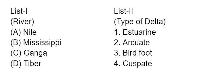
#92. Match List-I with List-II and select the correct answer from the codes given below —
#93. Which one of the following Oceanic currents is not associated with the Pacific Ocean?
#94. The Blue Nile river originates from—
#95. The correct sequence of the following seas from West to East is —
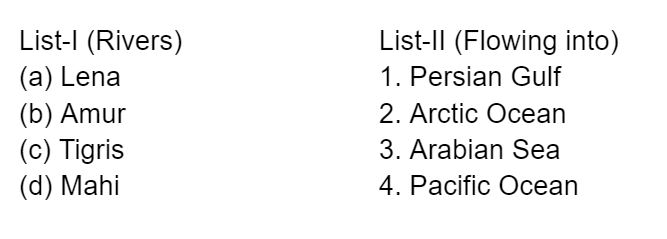
#96. Match List-I with List-II and select the correct answer from the code given below the lists:
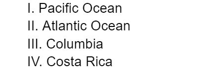
#97. The Panama Canal joins—
#98. Consider the following statements:
1.The annual range of temperature is greater in the Pacific Ocean than that in the Atlantic Ocean
2.The annual range of temperature is greater in the Northern Hemisphere than that in the Southern Hemisphere.
Which of the statements given above is/are correct?
Statement 1 is incorrect. ‘The size of the oceans and the seas affects annual range of temperature e.g., bigger the size, lower the annual range and vice versa. ‘Ihe Atlantic Ocean records relatively higher annual range of temperature than the Pacific Ocean due to this reason.
Statement 2 is correct. The temperature of ocean water varies in the northern and the southern hemispheres because of dominance of land in the former and water in the latter. The oceans in the northern hemisphere receive more heat due to their contact with larger extent of land than their counterparts in the southern hemisphere and thus the temperature of surface water is comparatively higher in the former than the latter.
Other factors affecting the distribution of temperature of ocean water include:
Latitudes: “The temperature of surface water decreases from equator towards the poles because the sun’s rays become more and more slanting and thus the amount of insolation decreases poleward accordingly.
Prevailing wind: Wind direction largely affects the distribution of temperature of ocean water. The winds blowing from the land towards the oceans and seas (e.g., offshore winds) drive warm surface water away from the coast resulting into upwelling of cold bottom water from below.
Ocean currents: Surface temperatures of the oceans are controlled by warm and cold currents. Warm currents raise the temperature of the affected areas whereas cool currents lower down the temperature. For example, the Gulf Stream raises the temperature near the eastern coasts of N. America and the western coasts of Europe.
#99. Between India and East Asia, the navigation-time and distance can be greatly reduced by which of the following?
1. Deepening the Malacca straits between Malaysia and Indonesia.
2. Opening a new canal across the Kra isthmus between the Gulf of Siam and Andaman Sea.
Which of the statements given above is/are correct?
Statement 1 is incorrect. Ihe current depth of Strait of Malacca is 25 metres, which prohibits entry of some of the biggest ships in the world. However, deepening it will not reduce navigation-time and distance to be travelled.
Statement 2 is correct. The Kra Isthmus is the narrowest part of the Malay Peninsula. Kra canal is a proposed canal which would reduce the travel time by eliminating need of going around the Malay peninsula, and reducing a distance of nearly 1,200 kilometres.
#100. La Nina is suspected to have caused recent floods in Australia. How is La Nina different from El Nino?
1. La Nina is characterised by unusually cold ocean temperature in equatorial Indian Ocean whereas El Nino is characterised by unusually warm ocean temperature in the equatorial Pacific Ocean.
2. El Nino has adverse e ect on south-west monsoon of India, but La Nina has no effect on monsoon climate.
Which of the statements given above is/are correct?
Statement 1 is incorrect. La Nina is characterised by unusually cold ocean temperatures in the Equatorial Pacific compared to El Nino Whereas El Nino is characterized by unusually warm ocean temperatures in the Equatorial Pacific.
Statement 2 is incorrect. La Nina is favourable to Indian monsoon whereas, El Nino has adverse effect on south- west monsoon.
#101. Consider the following factors:
1. Rotation of the Earth
2. Air pressure and wind
3. Density of ocean water
4. Revolution of the Earth
Which of the above factors influence the ocean currents?
Option 1 is correct. Rotation of Earth leads to Coriolis effect which influences direction of ocean currents. The Coriolis effect causes air and water to move towards the right in the northern hemisphere and the left in the southern hemisphere.
Option 2 is correct. Wind is the primary force driving surface currents in the ocean. Warm air masses form where the sun’s radiation is most intense, which is at the equator, this becomes an area of low pressure. Cold air masses form at the poles, where the sun’s radiation is less intense, this becomes an area of high pressure. Rising warm air travels from low pressure to high pressure, resulting in wind. “The dominant wind patterns drive oceanic currents.
Option 3 is correct. The density of ocean water influences the speed of the ocean currents. Also, denser water tends to sink, while relatively lighter water tends to rise.
Option 4 is incorrect. Revolution of Earth does not influence the movement of Ocean Currents. Insolation, Planetary winds, Gravity, Salinity of ocean water, Shape of coastline are some other important factors which influence the movement of ocean currents.
#102. The most important fishing grounds of the world are found in the regions where
The meeting of the cold and warm water, on the other hand, produces favourable conditions for the growth of plankton, on which fish depend directly or indirectly for their food supply. Thus, the areas where warm and cold currents meet are the best fishing grounds in the world. For instance, Grand Banks in North America is an international fishing ground where the cold Labrador Current and the relatively warm Gulf Stream.
#103. e annual range of temperature in the interior of the continents is high as compared to coastal areas. What is / are the reason / reasons?
1. Thermal difference between land and water
2. Variation in altitude between continents and oceans
3. Presence of strong winds in the interior
4. Heavy rains in the interior as compared to coasts
Select the correct answer using the codes given below.
Statement 1 is correct. The continents get heated faster and get cooled faster in comparison to the Oceans. The annual range of temperature is high in the interior of the continent because places located in the interior of the continent are far away from the moderating influence of the sea.
Statements 2 is incorrect. Altitude affects the daily range of temperature and annual mean temperature but has negligible impact on annual range of temperature. Latitude affects the annual range of temperature. The annual range of temperature increases with increasing latitude.
Statement 3 is incorrect. Wind are generally stronger near the coasts compared to interior areas of continents.
Statement 4 is incorrect. Rainfall in the interiors of the Continents is generally low as compared to Coasts. It is because the rain bearing winds from seas and oceans tend to loss most of the moisture till they reach the interiors.
#104. Which of the following have coral reefs?
1. Andaman and Nicobar Islands
2. Gulf of Kachchh
3. Gulf of Mannar
4. Sunderbans
Select the correct answer using the code given below.
Option 1, 2 and 3 are correct. Coral reefs ideally require sunlight, clean water to sunlight through, Salt water, and abundant Planktons. In India, the major reef formations are found in the Gulf of Mannar, Palk bay, Gulf of Kutch, Andaman and Nicobar Islands and the Lakshadweep islands.
Option 4 is incorrect. Due to the presence of high volume of freshwater, coral reefs are not formed in Sunderbans.
#105. Turkey is located between
#106. What is the correct sequence of occurrence of the following cities in South-East Asia as one proceeds from south to north?
1. Bangkok
2. Hanoi
3. Jakarta
4. Singapore
Select the correct answer using the code given below:
The sequence of the given cities from South to North is Jakarta, Singapore, Bangkok and Hanoi.
#107. Tides occur in the oceans and seas due to which among the following?
1. Gravitational force of the Sun
2. Gravitational force of the Moon
3. Centrifugal force of the Earth
Select the correct answer using the code given below.
Statement 1 and 2 are correct. Tides are the rise and fall of sea levels caused by the combined effects of the gravitational forces exerted by the moon and the sun, and the rotation of the earth.
Statement 3 is correct. Tides occur due to an imbalance between the various forces acting on the ocean water at a point in time. In general, the tide-generating force is the difference between these two forces; i.e. the gravitational attraction due to the mass of the moon and the centrifugal force due to rotation of the earth. Together, the gravitational pull and the centrifugal force are responsible for creating the two major tidal bulges on the earth. On the side of the earth facing the moon, a tidal bulge occurs while on the opposite side though the gravitational attraction of the moon is less as it is farther away, the centrifugal force causes tidal bulge on the other side.
#108. Which one of the following countries of SouthWest Asia does not open out to the Mediterranean Sea?
21 countries including Albania, Algeria, Bosnia and Herzegovina, Croatia, Cyprus, Egypt, France, Greece, Israel, Italy, Lebanon, Libya, Malta, Monaco, Montenegro, Morocco, Slovenia, Spain, Syria, Tunisia, and Turkey share their border with Mediterranean Sea.
#109. Mediterranean Sea is a border of which of the following countries?
1. Jordan
2. Iraq
3. Lebanon
4. Syria
Select the correct answer using the code given below:
Option 1 is incorrect. Jordan is bounded to the north by Syria, to the east by Iraq, to the southeast and south by Saudi Arabia, and to the west by Israel and the West Bank. It opens into the Red Sea at its southern most point.
Option 2 is correct. Iraq is bordered to the north by Turkey, to the east by Iran, to the west by Syria and Jordan, and to the south by Saudi Arabia and Kuwait. It has access to Persian Gulf in the South
Option 3 and 4 are correct. Following countries have a shoreline at the Mediterranean Sea:
European countries: Spain, France, Italy, Malta, Monaco, Slovenia, Croatia, Bosnia and Herzegovina, Montenegro, Albania, and Greece.
Western Asia (Middle East):Turkey, Cyprus, Syria, Lebanon, Israel, and the Palestine Gaza Strip.
#110. Which of the following is geographically closest to Great Nicobar?
Sumatra, and Java are islands located in Indonesia. Option a is correct. With distance of 1192 kms Sumatra is geographically closest to the southernmost and largest of the Nicobar Islands i.e. Great Nicobar.
Option b is incorrect. Distance between Great Nicobar and Borneo islands is 2398 kms. Borneo islands lies in Malay peninsula and it is shared by Malaysia, Indonesia and Brunie.
Option c is incorrect. Distance between Great Nicobar and Java islands is 1817 kms.
Option d is incorrect. Distance between Great Nicobar and Sri Lanka is 1437 kms.

#111. Consider the following pairs:
Which of the pairs given above are correctly matched?
Pair 1 is correctly matched. Aleppo is a city in northern Syria. It used to be largest city of Syria before civil war broke out in 2011.
Pair 2 and 3 are incorrectly matched. Kirkuk and Mosul are cities located in Iraq. Kikuk is a region in Iraq which is claimed by the Kurds, who controlled it for a brief period in 2017. Mosul, located in Iraq witnessed major battles to defeat ISIS. Mosul was retaken from ISIS in 2017.
Pair 4 is correctly matched. Mazar-i-sharif is a city in Afghanistan, which witnessed a massive Taliban attack on Afghanistan Armed Forces in 2017. Also, Indian consulate in Mazar-i-Sharif was attacked in 2016.
Thus, all the places mentioned in the options are conflict ridden areas.

#112. Consider the following pairs:
Which of the pair given above are correctly matched?
All the regions mentioned have been in news for seeking autonomy from the countries they are located in.
Option a is correct. Catalonia is a autonomous region in Spain. They are seeking complete independence.
Option b is incorrect. Till 2014, Crimea was part of Ukraine. Following pro-Russian demonstrations, it was annexed by Russia.
Option c is correct. Mindanao is an Island in Philippines. Centuries of conquest first by Spanish and American colonial forces that had ruled the Philippine archipelago followed by Filipino Christian settlers have gradually turned Muslims into a minority group in Mindanao, triggering conflict over land, resources and sharing of political power.
Option d is incorrect. Oromia is a state in Ethiopia, which has seen struggle for autonomy in the past by the Oromo people.
#113. Consider the following statements:
1. Most of the world’s coral reefs are in tropical waters.
2. More than one-third of the world’s coral reefs are located in the territories of Australia, Indonesia and Philippines.
3. Coral reefs host far a greater number of animal phyla than those hosted by tropical rainforests.
Which of the statements given above is/are correct?
Coral reefs are large underwater structures composed of the skeletons of colonial marine invertebrates called coral.
Coral polyps, the animals primarily responsible for building reefs, can take many forms: large reef building colonies, graceful flowing fans, and even small, solitary organisms.
Statement 1 is correct: Coral reefs are predominantly present in tropical shallow waters less than 50 meters deep. Coral reefs can be found in tropical destinations around the world, mostly in areas around the equator where the water is warmer. More than 100 countries have a coral reef within their borders, and over half of the world’s coral reefs are found within six countries: Australia, Indonesia, Philippines, Papua New Guinea, Fiji, and the Maldives.
Statement 2 is correct: Global distribution of corals- Australia-17% Indonesia- 16% Philippines-9% So, Australia, Indonesia and Philippines together host more than one-third of world’s corals.
Statement 3 is correct: It is estimated that more than 25,000 described species from thirty-two of the world’s thirty-three animal phyla live in coral reef habitats. It is around four times the number of animal phyla found in tropical rain forests.
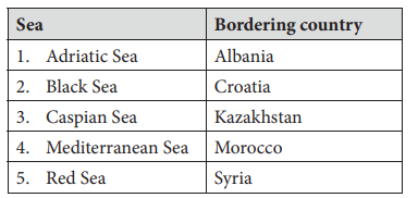
#114. Consider the following pairs:
Which of the pairs given above are correctly matched?
Option 1 is correct. A riatic Sea or ers ania.
Option 2 is incorrect. Black Sea borders Russia, Turkey, Georgia, Romania, Ukraine and Bulgaria. Adriatic Sea borders Croatia.
Option 3 is correct. Russia, Iran, Azerbaijan, Kazakhstan and Turkmenistan are countries bordering Caspian Sea.
Option 4 is correct. Morocco which lies in North western Africa borders the Mediterranean Sea near Strait of Gibraltar.
Option 5 is incorrect. Red Sea borders Egypt, Sudan, Yemen, Saudi Arabia, Eritrea and Djibouti The Mediterranean Sea borders Syria.
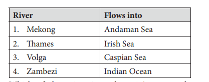
#115. Consider the following pairs:
Which of the pairs given above is/are correctly matched?
Option 1 is incorrectly matched. Mekong river originates in Tibet, flows through China, Myanmar, Laos, ‘Thailand, Cambodia and Vietnam before draining into the South China Sea. It does not reach the Andaman Sea.
Option 2 is incorrectly matched. Thames is the longest river of England. It flows through the Thames Estuary before draining into the North Sea.
Option 3 is correctly matched. Volga is the longest river of Europe. It Rises in the Valdai Hills northwest of Moscow, and discharges into the Caspian Sea
Option 4 is correctly matched. Zambezi is a major river of Africa. It originates in Zambia, flows through Angola, Namibia, Botswana, Zimbabwe and Mozambique before draining into the Indian Ocean.
#116. With reference to Ocean Mean Temperature (OMT), which of the following statements is/are correct
1. OMT is measured up to a depth of 26°C isotherm which is 129 meters in the south -western Indian Ocean during January–March.
2. OMT collected during January –March can be used in assessing whether the amount of rainfall in monsoon will be less or more than a certain long -term mean.
Select the correct using the code given below:
Ocean Mean Temperature (OMT) is an important climatic parameter required for atmospheric and oceanic studies like cyclone and monsoon predictions and ocean heat transport estimations.
Statement 1 is incorrect. OMT is measured up to a depth of 260C isotherm, is seen at depths varying from 50-100 metres. During January-March, the mean 260C isotherm depth in the South-western Indian ocean is 59 metres.
Statement 2 correct. OMT collected during January March can be used in assessing whether the amount of rainfall in monsoon will be less or more than a certain long-term mean. Using OMT data collected during January-March 2018, it was able to predict with greater probability of the pattern of monsoon.

